Map 2: Elizabeth's Lands and Manors, 1547–1558
* denotes lands Elizabeth gained or lost in 1551
- 1. Missenden
- 2. Moulsho
- 3. Newport Panell
- 4. Hanslope
- 5. Castlethorpe
- 6. Ashridge
- 7. Linforde
- 8. Little Lynforde
- 9. Slopton
- 10. Farneham Royal
- 11. Langley Meres
- 12. Risborough
- 13. Aspeley Geyes
- 14. Olde Warden
- 15. Evirshott
- 16. Shitlington
- 17. Barton
- 18. Cranefelde
- 19. Berkehampsted
- 20. Hemelhampsted
- 21. Redborn
- 22. Standgrounde
- 23. Yasley
- 24. Weston
- 25. Brington
- 26. Bythorn
- 27. Hallywell
- 28. Nedyngworthe
- 29. St. Ives
- 30. Houghton
- 31. Witton
- 32. St. Neots
- 33. Brampton
- 34. Apethorpe*
- 35. Wadehow*
- 36. Woodnewton*
- 37. Tansor*
- 38. Yarwell*
- 39. Yelvertofte
- 40. Moulton
- 41. Wendlingborough
- 42. Collyweston
|
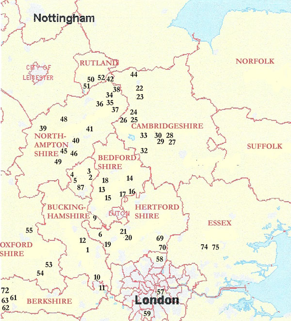
- 43. Torpell
- 44. Maxey
- 45. Cotton
- 46. Hardingston
- 47. Hardyngstowe
- 48. Navesbye
- 49. Blackesley
- 50. Preston
- 51. Uppingham
- 52. Baroughdon
- 53. Watlington
- 54. Ewelme
- 55. Bekeley
- 56. Caister
- 57. Durham Place
- 58. Enfielde
- 59. Worcetour
- 60. Radley
- 61. Donnington
- 62. Hampsted Mershall
- 63. Newberry town
- 64. Marnehull
- 65. Sturmyster
- 66. Wetherston
- 67. Buckelande
- 68. Bulberne
- 69. Hatfield
- 70. [Cheshunt]
Crown property in the
keeping of Sir Anthony Denny
- 71. Bysleigh*
- 72. Benham Valence*
- 73. Maynfeldes*
- 74. Canonbernes*
- 75. Canons*
- 76. Norton Bawson*
- Other lands in Devon not plotted on map
- Source: J. L. McIntosh
|