Appendix D
Taiwan in Antique Maps
(also see Media Index)
This appendix is a virtual museum exhibit. The reader is invited to explore the history of Taiwan through these European maps, which are among the most important visual sources for the study of seventeenth-century Taiwan.
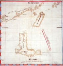
 Map of Dutch Fortress on Penghu, c. 1623 Map of Dutch Fortress on Penghu, c. 1623 |
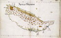
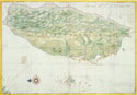 Map of The Island of Formosa, 1636 Map of The Island of Formosa, 1636 |
 Bird's-Eye View of Fort Zeelandia and Warehouses, 1635 Bird's-Eye View of Fort Zeelandia and Warehouses, 1635 |
 Bird's-Eye View of Zeelandia, c. 1652 Bird's-Eye View of Zeelandia, c. 1652 |
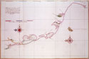 Map of the Western Coast of Taiwan, Tayouan and Points South, c. 1636 Map of the Western Coast of Taiwan, Tayouan and Points South, c. 1636 |
 Map of the Western Coast of Taiwan, Tayouan and Points North, c. 1636 Map of the Western Coast of Taiwan, Tayouan and Points North, c. 1636 |
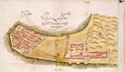
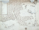
 Map of Roads and Cultivated Fields in the Saccam Area, 1644 Map of Roads and Cultivated Fields in the Saccam Area, 1644 |
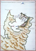
 Map of Luzon, Isla Hermosa (Taiwan), and a Part of the Coast of China, 1597 Map of Luzon, Isla Hermosa (Taiwan), and a Part of the Coast of China, 1597 |
 Map of the Spanish Port in Jilong, Taiwan, 1626 Map of the Spanish Port in Jilong, Taiwan, 1626 |
 Map of Danshui and Surrounding Areas, Including the Island of Jilong, 1654 Map of Danshui and Surrounding Areas, Including the Island of Jilong, 1654 |
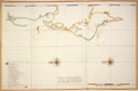
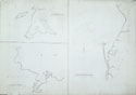 Navigation Charts of Jilong and the Bay of Tayouan Navigation Charts of Jilong and the Bay of Tayouan |
 Map of Formosa, c. 1652 Map of Formosa, c. 1652 |